| Home Page | Russian | |
TYPES OF RURAL SETTLEMENTS
IN ALTAI TERRITORY
By K.V. Gregoritchev
Process of Russian people settling in Altai was tightly connected with formation of a new settlement structure in the region. Due to prevalence of nomadic lifestyle of native population at the time when Russian colonization began along with low population density in the area (especially on the left bank of river Ob between rivers Alei and Charish) the development of settlements system shaping since the XVIIIth ńentury was greatly influenced by the following factors:
As a basis for grouping the types of regional settlements we used the following criterias:
Traditional farming settlements in Altai are conventionally divided into two large groups: permanent and seasonal.
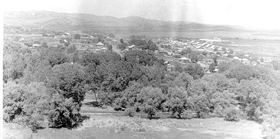
The first group includes "derevnia"s, simple villages, independent settlements with developed economy system and "selo", villages-centres, that were administrative, religious, economic and traid centres for several surrounding villages and other settlements. Customary attribute of a village-centre was a church. In the XXth century large villages had several churches with different parishes. Altai was peculiar for large sizes of such settlements that was caused by small population on one hand, and by low level of agricultural development of the area on the other. This feature was especially vivid in 1920s when some villages-centres in Altai had over 5 thousand people.
Due to significant increase of population and extension of villages the end of the XIXth - the beginning of the XXth century brought to life new types of peasant settlements: "viselki" – independent farming settlements formed by people coming of a large village that keep economical and demographical connections with the main village of origin and new settlements – permanent settlements formed in places where out-of-the-region settlers were concentrated. Being not so large, viselki stood rather close to the original village. The new settlements sprang up in poorly developed regions (western and south-western stepp regions, north-eastern foothills). As a rule these settlements had a few dozens of households.
Seasonal settlement were "zaimki" temporary settlements situated close to permanent settlement and economically inseparable from it. The owner of such a settlement would live in a village and would go to zaimka for land cultivation, therefore zaimka was built close to farming land. The other type of seasonal settlement were hunting houses, located in remote districts and occasionally used by fur-hunters. In Altai region they were rare, mainly in north-eastern taiga regions.
Main characteristics for settling type (situation of the settlement in specific location due to physical and geographical conditions) is its connection to natural and/or social-economical objects.
Primary settling of Altai (left bank of river Ob, then basins of rivers Alei, Charish, Barnaulka and Kasmala) was generally "peasant colonization" when main role in development of new lands and attaching them to Russian state belong to peasantry. In settling peasants were coming from their household needs when laying down a new settlement. Therefore most of rural settlements of the XVIIIth century were founded in places where 1-2 tributaries flow into large river. This tradition reflected in names of peasant settlements that often started with "Ust-" (meaning "river mouth") - vil. Ust-Charishskaia, Ust-Barnaulskaia, Ust-Kalmanka and others. This resulted in a well-developed network of settlements formed in Altai in the first half of the XIXth century, mostly of valley (riverside) settling type situated along large natural water bodies.
Since the second half of the XIXth century great inflow of settlers from European part of Russia (central and southern regions, Volga area, Ukraine) results in gradual altering of homogeneous riverside settling type. After most of the convenient locations along rivers and lakes were occupied peasants found that they have to develop watersheds and dry stepp regions (western part of Kulundinsky Plain). This process was especially intense in the years of large migrations to West Siberia caused by agrarian reformations by Stolipin. As a result to the end of 1920s in western areas of Altai territory the part of watershed typesettlements increased greatly. In these settlements the main source of water were wells, and for households needs thaw water of man-made pools (called "lozhki") was used.
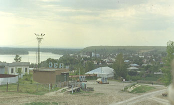
Intense development in the XXth century of inner and outer economical contacts brought to life a think network of roads and significant increase of their importance. The consequece of this process was boost of settlements related to large highways, so-called roadside type of settling entirely dependent in its development on the highways. In some cases when a highway crossed through a settlement built earlier (for example of valley-riverside type) it formed mixed type of settlement (valley-riverside + roadside type). Prevalence of connection to social and economical objects, first of all to the roads (including railroads) became the trend of settlement evolution in the XXth century.
The planning of rural settlements up until 1930s mainly was determined by physical and geographical conditions and settlers' traditions. Due to prevalence of riverside type of settlements until middle of the XXth century the planning was determined by the bank line. As a rule these settlements had linear planning and stretched along the large river from the mouth of its tributary (vil. Ust-Kalmanka, Sarasa, Kabanovo and others). Settlements built on a lake's shore often had arc planning coping the shore line.
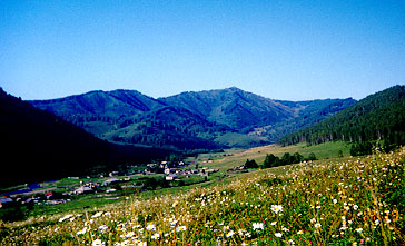
Relief was another natural and geographical factor for planning. Thus, for example, deep ravins along steep banks of river Ob instead of usual parallel to the river planning set the perpendicular direction that limited sizes of settlement (vil. Ust-Pristan). In foothills and mountainous regions radial planning is often found (streets going out of central square of the village in gorges between vertical folds.
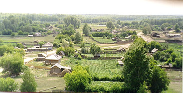
In villages situated along relatively straight section of a river the first streets were built up spontaneously with houses on either one or both sides. This type of building supposed "single-row" streets (farmhouses built along one side of the street) and later "double-row" streets (with houses along both sides). Such street building is more typical for large villages being administrative or parish centres. In other villages located in river bends (called "zaboki") the other building type was formed: scatteredor cluster building. With this building type 2-3 estates of close relaves were located independently of streets order to be approached from either side. Often an estate could have several houses build on its area. Formation of these "clusters" was linked to family division or simultaneos settling of several relatives or families coming from one area. Cluster building type was gradually superseded by street building type and by street-block type, its later modification. In the XXth century clusters remained only on outskirts or in settlements that didn't undergo significant building transformations.
Settlements belonging in the XVIII century to Kolivano-Kuznetski defence line were quite distinct in their planning and building. These settlements were peculiar for street-block building type with precise division into streets connected by lanes that was regulated by military authorities. In these settlements the estates had small sizes and household structures were taken behind blocks (behind outskirts). In spite of diminishing of these model attributes that started even in the XIXth century, many old residents recall broad and straight streets ("enough for four two-horse carriages to go") and small neat estates. in some settlements the remains of primary regular building still can be traced (vil. Verh-Aleiskoie, Tretiakovsky region).
In the XXth century the weighty role in planning and building of settlements goes over to authorities. In the XVIIIth - XIXth centuries they managed development of only military and industrial settlements along with some settlements of migrants (for example of Pole old believers), and in years of mass migration to Altai the goverment officials determined location for settling of migrants and created standard plans of settlements building. The full regulation of the settlement development, however, falls on 1940s-1980s, when building of central squares of large villages was allowed only by standard plans, and building of personal houses was directed by special permit of authorities. This tendency led to standardizing of building and planning of main villages, loss of individual features and ruining of traditional planning and building pieces and of many samples of antique architecture.
Settlements of old residents and migrants
Representatives of ethnographical group of old residents were the first to begin development of new areas in Altai and founding permanent settlements they occupied the most conveniet places along the largest rivers (Ob, Charish, Alei, Biia, Katun) and their tributaries. For this reason most of these settlements belong to riverside (valley-riverside) type. The exeption was secret settlements of runaways and old believers, hiding from authorities and official church, who built their settlements in hardly accessible locations, sometimes away from natural water bodies (in taiga and mountain regions). This pattern of settlement location was fixed also owing to ethnic and cultural traditions of northern Russia borne by old residents.
In villages of old residents building was primarily of the cluster type without street order, where houses stood on long distance from each other. Gradual growth of settlements led to rows and then to street building. This process combined with considerable "stretch" of a settlement (for example vil. Sarasa of Altai region is over 7 km long), and the lanes going between houses were rather far from each other. In central parts of large villages in area of market squares and administrative centres building was tighten up, church and administrative buildings formed an architectural ensemble. Cluster building was pushed out to outskirts where it remained partially until nowdays. In riverside settlements "zarechie" ("beyond the river") was formed - later part of settlements built on the other bank. An important road going through a settlement brought changes in orientation towards itself as new-built houses were set facedes towards the road.
Names of old resident settlements typically have endings "-ha", "-ka", for instance, Chekaniha, Solonovka. In mountain regions there are many names of old resident settlements originating from Turkic languages (Sarasa, Kirkila). Due to numerous official reforms some old resident settlements were renamed though their old names still remain in verbal use (Griaznuha, renamed into Sovetskoie).
Considerable part of migrant settlements that appeared in the second half of the XIXth - in the beginning of the XXth centuries consists of watershed type ones (eastern, southern and north-eastern regions of the territory). Representatives of this ethnographical group bore as traditions of southern Russia so urban culture traditions that penetrated rural society in the second half of the XIXth - the beginning of the XIXth century. They shaped new settlements by order with highlighted planning of streets and blocks. Such settlements typically have high density of building, smaller estates, and houses with front gardens.
In those places where migrants settled in old-resident villages their primary features went through gradual diminution. In old-resident settlements included in the research that have experienced significant influence of migrant culture we noticed substition of cluster building type with street type, greater density of building, and new parts called "ends" (or "sides") where new-comers lived close to each other connected either through blood relations or similar place of origin. This division into "ends" can be traced in many villages even in nowdays.
Thus, in the beginning of the XXth century rural settlements in Altai underwent gradual reduction of features typical for traditions of certain ethnic groups on one hand and their integration based on adaptation to specific physical, geographical, and climate conditions.
The following decades brought further dissimilation of ethnic traditions in Altaian settlements. The most important trends in this process were stimulation towards large-scale production (large farms, industry building, etc.), standardization of building in trading and administrative centres, ideological pressure (destruction of churches, erection of standard monuments of Lenin, memorials), unification of administrative, trading and partially dwelling houses architecture, prohibition of unauthorized individual construction. Since the end of 1980s - beginning of 1990s the mentioned trends nearly ceased for a number of economical and political reasons.
| Traditions | Monuments of Peasant Architecture | Bibliography | Authors | Site Map |