|
Russian
Central Asia and the Altai Territory
We will appreciate your suggestions,
questons on cooperation
in the following address
lik@bspu.secna.ru
or write to the
guestbook
Map Site
|
Regional geography.
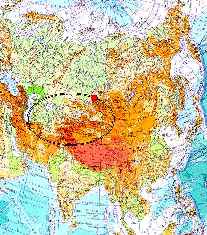
The Altai Mountains are situated in the North-East of geographic and hisorical-
cultural province, which is called Central Asia (marked in the picture
with the oval).
The great siberian rivers the Ob and the Irtish spring there. The southern part
of the West-Siberian plane adjoins the central-asiatic natural habitat
territorially. Just on the border of the Altai Mountains and the West-Siberian
plane the Altai Territory is situated - one of the subjects of Russian
Federation (marked in red).
Regional history.
The Russians settled on the Ob upper reaches at the end of the XVIth century.
But the Altai Territory stayed up to the beginning of the XVIIIth century
outside the Russian State. The annexation of this region to Russia began,
when Peter 1. reigned. The economical opening up of the territory
in the XVIIIth-XIXth century is connected with the iron store treasures
of the Altai Mountains.
Process maping history.
The first west-europian maps, where the mouth of the Ob is marked,
went back to the middle of the XVIth century. The earliest among them
are believed to date from the 2d. half of the XVIIth century
Historical maps.
Our work presents historical maps of two kinds. Some of them are
the simplyfied copy of the original designs in the XVIIth-at the beginning
of the XXth century. The others are created by modern researchers as result
of a thorough investigation of different histoical sources
The additional supplement will make it easy for You to find the informatoin
You need.
|