The first half of the XVIIth century
The second half of the XVIIth century
The first half of the XVIIIth century
The second half of the XVIIIth century
The first half of the XIXth century
The second half of the XIXth century
Beginning of the XXth century
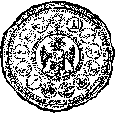
The State Seal of Ivan the Terrible (1583)
Fragment. The Siberian land emblemon the State Seal of Ivan the Terrible.
|
For the first time russian cronicals mention "the Siberian Land" in 1406.
This state originated on the West-Sibebirian plane as a result of a break-up
of the Chingis Khan's empire. In the middle of the XVIth century the Siberian
empire streched from the eastern slopes of the Ural Mountains to the Ob middle reaches.
The present-day Altai Territory was situatd outside this country. Nearly no records
are cept about the tribes, who lived there in the XVth-XVIth century. Nor there
are trustworthy archeological finds, dating back to that period. But we can hardly
make a mistake supposing that in the Upper Ob-side surrounded by the Ob and the
Irtish there were cattle-breeders at that time. Apparently this people was mainly
Turcik-speaking, although the records of some encampments of Mongolian-speaking
"oirats"(old mongolian tribes, or "kalmik", as the Russians called them) on borders
of the XVIth-XVIIth century are mentioned.
The basis of this "oirat union", formed at the end of the XIVth century, was
the west-mongolian community of the tribes. We can't say for certain, where the North-
Western border of the settlements of the oirat tribes at the beginning or in the
middle of the XVIth century lay, when they started the economic exploration of the
Ob-Irtish planes, and if this natural habitat adjoined the Siberian empire. In the
scientific literature there is an opinion that oirats could move their nomad encampments
to the North approximately to the middle of the river Om and the present-day Novosibirsk
only at the end of the XVIth century, with the doom of the Siberian empire,
fostering them.
The events at the end of the XVIth century, when the doom of the Khan Kuchum empire
was caused by the russian service troops, sent from the Ural Mountains, became a
turning-point in the history of sibirian regions and its people. The russian
possessions, which were reflected on the political map of the Northern Asia,
appeared and started growing rapidly. It influenced the destiny of many siberian
generations and it also considerably predetermined the charakter of the history
of the Siberia and the Altai Territory.
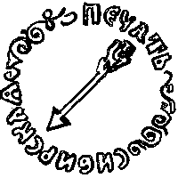
Among the emblems of the lands pertaining to the Russian Federation there was "the
Siberian Seal" with the oldest russian symbol - image of an arrow - drawn on it.
|