Physics-geographical division into regions
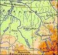
The Altai Territory is a component of the Russian Federation. It is situated in
Southern Siberia, on the border of two vast territories: the West-Sibirian
plane and the Altai mountains. There the biggest siberian river Ob springs.
The flat country exceeds to a considerable extent the mountain range
both in the area and in the density of population. 8 of 11 cities are situated
on the plane, including the capital - Barnaul.
Geological division into regions
The mountainous part of the region includes spurs of Altai's ridges and
the Salair Ridge, addjoining it from the North. The geologists distinguish
the Mountainous Altai and the Mining Altai, according to the peculiarities
of the mountain formation.
Hydrological division into regions
The main water artery is the Ob. The region is situated mainly
in borders of the Ob water-collecting basin. The hydrologists subdivide it
(within the region) into the Upper Ob and the Middle Ob basin. On the west
in the place between the Ob and the Irtish several rivers flow, which belong
to the inner outflow and to the region without any outflow of the Kulunda
plane.
Present-day administrative-territorial division into
regions
Today the Altai Territory is divided into 60 districts. There 11 cities and
towns, the biggest from them are Barnaul, Biysk, Rubtsovsk.
Accomodation of the population into regions
Representatives of more than 80 peoples live in the region. Over 85% of
the population the Russians constitute. The most numerous among the
representatives
of other nationalities are the Germans, the Ukrainians and the Altaiers.
Since the late 70-s the urban population has been exseeding the rural one.
The total number of population in the Altai Territory makes about 2,7 mln.
|

