|
The Altai Territory was established in 1937.
The new administrative unit got the status "region", because the territory of the
Oirot-Turinsk (later Gorno-Altaisk) autonomous region becamen a member of the Altai Territory. In 1991 the rights
of this region were broadened, it was proclaimed Republic Altai
as a member of Russian Federation.
The present-day Altai Territory doesn't occupie that mountainous land,
which gave it the name.
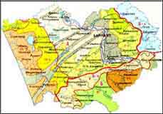
The Altai Territory occupies various physics-geographical regions,
from waterless steppes to high-altitude tundra and small glaciers.

Physics-geographycal regions
|