The first half of the XVIIth century
The second half of the XVIIth century
The first half of the XVIIIth century
The second half of the XVIIIth century
The first half of the XIXth century
The second half of the XIXth century
Beginning of the XXth century
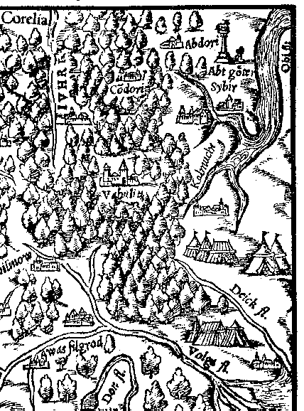
Fragment of Sebastian Muenster's map (1544).
The Ob is marked in the right upper corner
|
The first tries of west-europians cartographers to mark the Ob basin date back
to the middle of the XVIth century. The earliest draught of such kind is believed
to be the map of Antonius Vid's Moscow State, dated back to 1452. The Ob is shown
excessively wide, it looks like more a sea-bay, than a river. The town "Sibir"
is marked on Vid's map on the right bank of the Ob, and in the upper flow, near the
mouth of the river - "Tjumen Vilki" (Tjumen the Great).
In 1544 the works of the german geographer Sebastian Muenster "Cosmography"
were published. As a supplement there was a map of Moscovia, which was mush the same
of Vid's map (look at the illustration). The Ob on Muenster's map is drawn
so as on Vid's map. Sibir (on the left tributary) and Tjumen (on the Upper Ob)
were marked as towns, but the name was given only to the town Sibir. The specialists
suppose that Muenster's map is an overworked copy of Vid's map. At that the original
was a little distorted. Let's take the kalmiks as an example: Vid placed them on the
right bank of the Ob,to the south-east of its mouth, while Muenster placed them along
the left bank.
There is very little information about Antonius Vid: he was a painter, he lived
in Danzig (Gdansk). Muenster calls him a Lithuanian. Vid himself didn't visit Russia,
he compiled a map of Moscovia according to the surveys, which he got from Ivan Jatskoi
(Ivan Ljatskoi), who left Russia for Poland because of disgrace. So the maps are
based on the russian data.
The mouth of the Ob on Vid's (1542)and Muenster's map (1544)
is marked a little bit higher Tjumen. The same mistake we can see on the map of
Sigismund Gerberstein (1546), though he, unlike his predecessors, put the great lake
"Kithay lacus" - "China Lake" in the Upper Ob.Gerberstein reported in his "Notes"
about Moscovia (1549), that data about the Ob and China Lake were borrowed from the
russian guide-book.
So they started to mark the Ob on the west-europians maps in tne 40-s of the XVIth
century. All the necessary information, conserning the geographical position of
West Siberia, were got from russian informants. in the middle of the XVIth century
europians had no idea about the dimensions and the extent of the greatest siberian
river Ob. The Upper Ob Basin wasn't marked on maps of the XVIth century. The drawing
of the Upper ob and the Middle Ob reaches was not correct, even on the best model
- the map from the "Atlas" of the famous flemish geographer Gerard Merkator (1595):
heading for the fake town Grustin, situated on the left bank of China Lake.
|