Historical cartography of the Altai Territory Historical region studies Laboratory Historical faculty BSPU

Process maping history.The second half of the XVIIth century

Beginning of the part

The first half of the XVIIth century

The first half of the XVIIIth century
The second half of the XVIIIth century

The first half of the XIXth century
The second half of the XIXth century

Beginning of the XXth century


Title of the map, published in Germany by G.A.Schleissing
in 1690

There are no records about the russian maps dating back to the second half of the XVIIth century. Some particular draughts (towns and cities, districts etc.) were composed since the beginning of the XVIIth century in Siberia, in the Siberian department and in Moscow. But the first map, on which all the eastern lands of Russian State from the Volga to the Pacific Ocean are marked, was compiled only during the reign of Alekssej Michailovich. There are some proofs, that the first russian map of Siberia was drawn in Tobolsk in 1667-1668, according to the Tsar Edict. Due to the "Discription", attached to the draught,is known, that it was compiled, according to the different stories of people of all rangs.

The Tobolsk voivode Peter Godunov organized the map constracting work and supervised it. That's why the first russian survey draught of Siberian lands and contiguous territories is considered to be "Godunov's draught".It is also mentioned in the book of the famous Dutch geographer N.Vitzen "The Northern and the Eastern Tartaria" of the end of the XVIIth century: "Tsar, Alekssej Michailovich, ordered the Tobolsk viovode Peter Godunov and his companions in November, 15 in 1667 to explore the distance between the towns of Siberia and China. They compiled the map, that was published in Moscow as a woodcut with the discription of the distance between towns. Probably that's why the sources of the end of the XVIIth century call the draught of Godunov "printed".

Neither the original of the year 1667, no the printed separates were saved. The first copies of the handwritten original, sent from Moscow to Tobolsk, were made in the capital in 1669 by foreign ambassadors. Godunov's draught was changed a bit and printed in Europa by G.A. Schleissing.


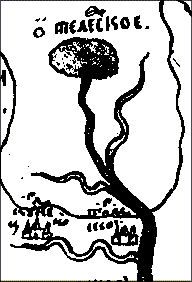
Fragment of Godunov's draught
with Teletskoje Lake

In our atlas You can see Godunov's draught 1667 as a copy, that was made at the end of the XVIIth century by the famous Tobolsk cartographer Simon Remezov. At the foot of the map an explanatory inscription was given:"The list of the original draught. And to this day there was no printed draught in Siberia, in Tobolsk."

Concerning the russian cartographical tradition of the XVIIth century, tha map was compiled due to the cardinal points, but the North is placed below, the South ("midday")- above. That's accounted for the main reference point was not the compass, bat the midday sun in its highest point. Though the compass was drawn on Remezov's copy, it was apprehended as a decorative component of the draught.

The Ob is shown considerably simplified along the whole stretch from the sources to the mouth, the most tributaries are not marked, and those, which were drawn, are not named. As a scheme it is shown, the Ob begins with the flowing together of two nameless rivers (the Bija and the Katun), while the eastern river springs from Teleschskoje Lake (Teletskoje). In the Low Ob a big tributary is marked flowing into the Ob from the East (we can suppose, it is Tshumish). The cities "Kuznetskoi" and "Tomskoi" are situated on the next eastern tributary (the Tom). The southern border of russian possessions is marked on Godunov's draught (1667) approximately between the Tom and the Tshumish mouths. The Altai Territory was situated at that time outside the Russian Empire. The basin of the Tshumish, the Bija and the Katun, and also the Altai Mountains (near Teletskoje Lake) and joining them the Sajan Ridge are shown as a place, where the "sajan people" lived.

Simon Remezov copied not only this original printed draught of Godunov, but also compiled on this basis at the end of the XVIIth century his own map of the settlement of siberian people and their southern neighbours. Remezov's map considerably supplements and elaborates geographical realias, records on the draught.


Home
Map
Site
Regional
geography
History
of the region
Historical
maps
The additional
supplement