|
Beginning of the part
The first half of the XVIIth century
The second half XVIIth century
The first half of the XVIIIth century
The second half of the XVIIIth century
The first half of the XIXth century
Beginning of the XXth century
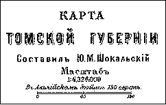
Title of the map of the Tomsk province,
published in the Brockhaus and Efron' Dictionary
|
In the second half of the XIXth century the publication of the printed maps of southern
West Siberia became quite a normal thing. At the end of the XVIIIth - the first
half of the XIXth century such maps were either additional supplement in all russian
geografical atlases, or supporting information to the traveller works. In the second
half of the XIXth century printed maps started to be widely-used for the illustration
of different kinds of scientific literature
In this part of of the electronic atlas we present
the map of the Tomsk province,compiled in the
beginning of the 1890-s, and later it was used in the famous many-volume "Encyclopaedia"
of F.Brockhaus and J.Efron. At that time the Tomsk province streched from Altai
glaciers to Vassugan marches, it exeeded any western russian province.
The Tomsk province was divided at the end of the XIXth century into 6 districts:
Tomsk, Kain, Mariinsk, Barnaul, Bijsk and Kuznetsk. In 1894 from the Bijsk one more
district was singled out - Zmeinogorsk. Since 1898 all the mentioned districts
were called "province", and in the Tomsk province one district remained - Altai.
The Altai district, ruled by the Tsar Cabinet, embraced the territory of the
Barnaul, Kuznetsk, Bijsk, Zmeinogorsk disctricts (since 1894),and also 5 southern
villages of the Tomsk province. Its northern border didn't follow the all russian scheme
of the territorial division into districts and villages.
The map, availiable here, is one of the first, on which the Transsiberian Railway,
built ih the 1890-s from the Ural to the Pacific Ocean, is shown. The main line
crossed the Altai district in the North, now it is beyond the Altai Territory.
It is of interest to mention that in the place, where the railway and the Ob crossed,
two stations Krivoschekevo and Ob are marked. The latter gave rise to the village
Novo-Nikolajevsk,that later rose to the status of the city (Novosibirsk). On the maps
of the XXth century in place of Ob Novo-Nikolajevsk was mentoned.
You can get the general idea how Western Siberia was shown in the europian cartographical
publications at the end of the XIXth century, by looking through the fragment of the map
from the english atlas, published in Edinburgh in 1882.
Blackie & Sons Atlas (Edinburgh, 1882)
|